CHAPTER IV
NORTHWESTERN OHIO AND THE BLACK SWAMP
Description and History of the Counties of Allen, Auglaize, Defiance, Fulton, Hancock, Hardin, Henry, Lucas, Mercer, Paulding, Putnam, Williams and Wood—Life Among the Pioneers—The Indian Character, Customs and Religion Described—Corn Fields and Gardens of the Red Men—A Game of Indian Foot Ball—Indian Wars—Famous Chiefs—Story of the Notorious Girtys—Battles and Incidents of the War of 1812—Famous Generals of the Civil War—Discovery of Oil and Gas—The Grand Reservoir —Population Statistics.
ALLEN COUNTY.
This county was formed April 1, 1820, being named for Col. Ethan Allen, of Revolutionary fame. It was formed out of the lands obtained from the Indians, in the treaty of 1818. Its history during the stirring times of the War of 1812 and the Indian wars was confined to the western part of the county. In 1812 Colonel Poague, of General Harrison's army, built a fort on the west bank of the Auglaize River, and named it "Fort Amanda" for his wife. In the following year there were a number of scows built here for the navigation of the Auglaize River which was then navigable for fair-sized flatboats and pirogues. A national cemetery was established here. The first settlers in the county located at Fort Amanda in 1817, and the first white child born in the county was born here to Andrew Russell and wife and became the wife of Charles C. Marshall, a longtime resident of Delphos. Samuel McClure settled on the Ottawa River, northwest of Lima, in 1825. His nearest neighbors at that time lived near Fort Amanda and near Roundhead. In 1826 Morgan Lippincott, Benjamin Dolph and Joseph Wood settled on Sugar Creek. Lima, the county seat, was laid out by Capt. James Riley in 1831, on land purchased by the State of Ohio .for that purpose, and afterwards paid for by the commissioners out of the proceeds of the sale of lots. In August, 1831, the name was suggested by Judge Patrick G. Goode. Among the first settlers in Lima, were Absalom Brown, John P. Mitchell, John F. Cole, Dr. William Cunningham, John Brewster, David Tracy, John Mark and John Bashore.
Robert Bower, who came to Lima with his parents in 1834, and who knew every man and child in the town, says in his reminiscences that the latch strings of the citizens were always out and they were always ready to share the last pint of meal with the needy, regardless
AND REPRESENTATIVE CITIZENS - 41
of where the next was to come from. As the nearest mills were at a great distance and there were no roads to speak of, they had recourse, and mills and the tin grater. He says: daily labor was to gather corn and dry in a kiln, after which I took it on a grater made from an old copper kettle or tin bucket, and, after supper made meal for the johnnycake for breakfast; after breakfast I made meal for the pone for dinner; after dinner, I made meal for the mush for supper."
Their house was up to date, was made of round logs, with clapboard roof, and puncheon
floor, and had a parlor, dining room, kitchen and work shop, but for convenience sake all were in one.
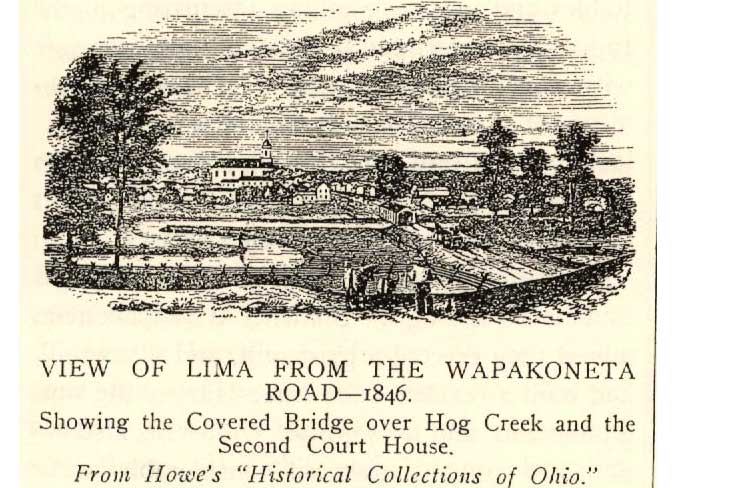
The changes that have taken place in the last 70 years are wonderful. The Ottawa River, that was then called "Hog Creek." from the Indian words Koshko Sepe, which Count Coffinberry changed to Swinonia in one of his poems, is now only sufficient for drainage for the city and surrounding country. In former years when high water came, it was weeks before they subsided. The growth of Lima was greatly accelerated by the discovery of oil by Benjamin C. Faurot in drilling for gas. And it is safe to say that Lima owes her prosperity more to Benjamin C. Faurot than to any man that has ever lived there.
The population of the cities and villages of Allen County was as follows in 1900:
LaFayette |
316 |
West Cairo |
338 |
Harrod |
370 |
Elida |
440 |
Beaver Dam |
477 |
Bluffton |
1,783 |
Spencerville |
1,874 |
Delphos (2,289 in Allen County) |
4,517 |
Lima |
21,723 |
Allen County in 1830 had a population of 578; in 1900 the population was 47,976.
AUGLAIZE COUNTY
Was formed in 1848, from parts of AIlen, Putnam, Van Wert, Mercer, Darke, Shelby and Logan counties, and is the southern extremity of the Black Swamp. It occupies the dividing line between the waters of Lake Erie and the Ohio River. The writer recollects, when a boy, of hearing a man say that he lived on the very top of the dividing ridge and that when he filled his hog trough too full, what ran out of the south end ran to the Ohio River, and what ran out of the north end ran to Lake Erie.
The Shawnee Indians had their headquarters at Wapakoneta, and gave the name to the town. They remained there until they were removed west of the Mississippi in 1832. The following year Wapakoneta was platted by the original proprietors—Robert J., Skinner, Thomas B. Van Horne, Joseph Barnett, Jonathan K. Wilds and Peter Aughenbaugh.
Judge Burnet, of Cincinnati, who held court at Detroit in 1796, relates that in one of his trips from Cincinnati to Detroit on horseback, he stopped at Wapakoneta and called upon the old chief, Bohengeehalus, who received him kindly and called in some of the young men, requesting them to get up a game of foot ball.
42 - HISTORY OF VAN WERT COUNTY
A purse of trinkets was soon made up and all the village gathered on the lawn. The men played on one side and the women on the other. The rules did not allow the men to touch the ball with their hands on penalty of forfeiting the purse, while the women had the privilege of picking it up, running with it and throwing it as far as they could. When a woman had the ball, the men were allowed to catch and shake her and even throw her on the ground, if necessary to extricate the ball from her hand, but they were not allowed to touch or move it, except with their feet. At the opposite extremes of the lawn, stakes were placed about six feet apart. The contending parties placed themselves in front of the stakes, the men on one side and the women on the other The party that succeeded in driving the ball through the stakes at the goal of their opponents were the victors and received the purse. All being ready the old chief went to the center of the lawn and threw up the ball making an exclamation in the Shawnee language, when he immediately retired and the game began. The parties were very evenly matched, being about a hundred on a side. The game lasted more than an hour with great animation, but was finally decided in favor of the women, by the power of a woman who secured the ball and held to it, in spite of the men who seized her and attempted to shake it from her uplifted hand. She dragged them along until sufficiently near to throw it between the stakes. The women were most active and most frequently had possession of the ball: then the young men would immediately seize them and always succeeded in rescuing the ball but frequently not until their female competitors were thrown on the grass. When the contending parties retired from the field of strife, it was pleasant to see the feeling of exultation depicted on the faces of the victors.
David Robb, one of the agents for the removal of the Indians, had some great experiences among them. He says that intemperance prevailed to a great extent among the Indians. Yet there were those who refused to associate with those that drank. The temperate class cultivated their little farms with a degree of taste and judgment and some of them could cook a good meal and could make good butter and cheese. Many of them were quite ingenious mechanics, had a fair knowledge of the use of tools, and could manufacture all needed farm implements. He says there is, with all their foibles and vices, something fascinating in the Indian character, and one cannot long associate with them without having a growing attachment for them. He says the Indian is emphatically the natural man, and it is easy to make an Indian out of a white man, but very difficult to civilize and Christianize an Indian.
At an early day a Society of Friends was established among the Shawnee at Wapakoneta, where they erected a grist-mill, and a sawmill, and built a residence for Isaac Harvey the superintendent, and his family. Under his instruction, the Indians acquired considerable proficiency in farming and rapid progress in civilization, and in the acquisition of property. Domestic animals were introduced, and the horse brought into use to relieve the women of the labor of plowing the land, and carrying the burdens. After overcoming their parents' aversion to having their children educated, the young people made rapid progress in their studies. When the Indians were removed to Kansas, the Friends' mission, under the care of Henry Harvey, went along and there he remained until 1842.
St. Marys, on the bank of the Grand Reservoir, was noted in an early day as being the village of the Shawnees, with whom James
AND REPRESENTATIVE CITIZENS - 43
Girty lived. General Wayne gave it the name of "Girty's town".
It is also noted as being the last resting place that noble patriot and brave soldier, Gen. August Willich. When treason threatened the life of the nation, he offered his service as a private in the Ninth Regiment, Ohio Vol. Inf., and afterward helped raise the 32nd Indiana Regiment, composed of Germans, which he commanded until he was promoted to a brigadier general, in July, 1862. He was brevetted major general in 1865. He was idolized by the soldiers of his regiment and of the brigade, and had the confidence of the whole army. Where Willich ordered the men they were ready to go, knowing he would not send them where he was not willing to go himself.
At the battle of Liberty, in the opening of the Rosecrans campaign, General Willich took the gap with his brigade. Rosecrans characterized it as the finest fighting he witnessed during the war (the 15th and 49th Ohio belonged to his brigade).
At the battle of Mission Ridge, Grant gave his orders for the center to take the enemy's works at the foot of the ridge, and stay there. Willich's and Hazen's brigades were in the front, with Sheridan's and other brigades in the rear. The whole line moved in double-quick time through woods and fields and carried the works, Willich's brigade going up under the concentrated fire of batteries located at the point where two roads met. At this point General Willich saw that to obey General Grant's order and remain in the works at the foot of the ridge would he the destruction of the center; to fall back would be the loss of the battle with the sacrifice of Sherman. In this emergency, with no time for consultation with the division general or any other commander, he sent three of his aids to differentregiments and rode himself to the Eighth Kansas, and gave the order to storm the top of the ridge. This was done as if on parade, and was the wonder of the world, as to its conception and the brilliance of its conception.
New Bremen was settled in 1832 by a company organized in Cincinnati for the purpose of locating a town and colonizing it with Germans. On a tract of to acres they laid out 102 lots, each 66 by 300 feet. Each member was entitled to one lot and the rest were offered for sale at $25 each. The plat was recorded in Mercer County, June 11, 1833. The journey of the first six members of this company from Cincinnati occupied 14 days. This colony was composed of Protestants and a house of worship was built in 1833, at a cost of $40, which answered for both church and school.
Minster, also a German town, was organized in 1833 by a stock company from Cincinnati, and was settled by Catholics.
Auglaize County, in 1900, had a population of 31,192. Following is given a list of the cities and villages in the county, with their population in 1900:
Kossuth |
153 |
New Knoxville |
436 |
Waynesfield |
542 |
Cridersville |
581 |
New Bremen |
1,318 |
Minister |
1,468 |
Wapakoneta |
3,915 |
St. Marys |
5,359 |
DEFIANCE COUNTY.
This county was organized March 4, 1845, from Williams, Henry, and Paulding counties. It takes its name from Fort Defiance.
It was favorably situated for early settlement, for at an early day the Maumee, Tiffin, Blanchard, Auglaize, and Ottawa rivers, which center in it, were navigable for pirogues and
44 - HISTORY OF VAN WERT COUNTY
flatboats—the means by which the settlers were supplied with provisions for many years. The Tiffin from the north was navigable for about 5o miles; the Auglaize as far as Wapakoneta; the Blanchard for many miles; the Maumee as far as Fort Wayne, and then the St. Mary's as far as the town of that name, and the St. Joseph for quite a distance. All paid tribute to Defiance and provided markets for her surplus corn,
During the Indian occupancy it was headquarters for their meetings for, consultation and for trading. They could reach it by canoe and bring in their furs to the traders located along the Maumee. In October, 1792, the greatest Indian council ever known was held here. The council represented a larger territory than any ever held before or since on American soil. All the chiefs of all the tribes of the Northwest were here, representatives of the seven nations of Canada and of the 27 nations beyond Canada. Cornplanter and 48 chiefs of the Six Nations of New York were on hand. Three men of the Gore Nation were here, whom it had taken a whole season to reach the place of meeting. Cornplanter said that there were so many nations represented that he could not name them. The question of peace or war was long and earnestly discussed. The Shawnees were for war and the Senecas for peace.
A description of the character of the Delaware Indians, as given by John Bricknel, who was a prisoner four. years, is interesting. He was captured when nine years of age near Pittsburg, and adopted by a Delaware Indian, named Whingy Pooshies, and lived with the latter's family four years. He said he was treated very kindly, every way as one of themselves, and had every opportunity of learning their manners customs and religion. He thought he had been influenced for good more from what he learned among these Indians than from what he learned among the whites. Honesty, bravery and hospitality were cardinal virtues among them. When strangers came among them, they were not asked if they wanted anything, but a runner would start out, proclaiming, "Strangers have arrived." On this, every family provided of the best they had and took it to the strangers without a thought of receiving anything in return. When they took their leave, they were helped on their journey. They worshiped the Great Spirit, whom they called "Manitou." He said that he never on "even one occasion knew of their using the name irreverently." They had no term in their language by which they could swear profanely. The young honored the aged. The first corn that was fit to use was made a feast offering. The first game that was taken on a hunting expedition was dressed whole without breaking a bone, with the head, ears and hoofs; and being cooked whole, all ate of it, and what was left was entirely burned up. And in respect to things clean and unclean, they followed the Jewish custom. They had no public worship, except the feasts, but frequently observed family worship, in which they sung and prayed. They believed in the resurrection after death, and in future rewards and punishments. Their cruel treatment of their enemies in war seemed to be the carrying out of the precepts. "An eye for an eye, and a tooth for a tooth," and "Blood for blood."
When Bricknel was exchanged, the tribe came opposite the fort at Defiance, and "Whingy Pooshies told me that I must go over to the fort. The children hung around me crying and asking if I was going to leave them. I told them I did not know. When they got over to the fort and were seated with the officers, Whingy Pooshies told me to stand up, which I did. He then arose and addressed me with these words: 'My son, these
AND REPRESENTATIVE CITIZENS - 45
are men of the same color with yourself and of your kin may be here or they may be a great way off. You have lived a long time with us. I call upon you to say if I have not been a father to you. If I have not used you as a father would a son.' I said: `You have used me as well as a father could use a son. He said, ‘I am glad you say so. You have lived long with us. You have hunted for me, but your treaty says you must be free. If you choose to go with people of your own color, I have no right to say a word, but if you choose to stay with me, your people have no right to speak. Now reflect on it and make your choice, and tell us as soon as you make up your mind. I was silent for a few moments, in which time I seemed to think of most everything. I thought of the children I had just left crying. I thought of the Indians I was so attached to, and I thought of my people whom I remembered and this last thought decided, and I said would go with my kin. The old man then said : `I have raised you. I have taught you to hunt and you are a good hunter. You have been better to me than my own sons. I am now getting old and cannot hunt. I thought you would be a support in my old age. I leaned on you as a staff. Now it is broken, you are going to leave me, and I have no right to say a word, but I am ruined.' He then sank back in tears in his seat. I heartily joined him in his tears, parted with him, and have never seen or heard of him since."
O. M. Spencer, the 11 year old boy, who was captured about the same time that Bracknell was, gives this description of the location that afterward became the site of Fort Defiance. On the high ground extending from the Maume River, a quarter of a mile up the Auglaize, about 200 yards in width, was an open space, on the west and south of which were oak woods, with hazel undergrowth. Within this opening a few hundred yards above the point, on the steep bank of the Auglaize, were five or six cabins and log houses inhabited principally by Indian traders. The most northerly, a large, hewed-log house, divided below in three apartments, was occupied as a warehouse, store and dwelling by George Ironsides, the most wealthy and influential of the traders on the point. Next to him was the houses of Pirault (Pero) a French baker and M. Kenzie, a Scot, who in addition to merchandising followed the occupation of a silversmith, exchanging with the Indians his silver ear-drops and other silver ornaments at an enormous profit, for skins and furs. Still further up were several other families of French and English, and two American prisoners. Henry Ball, a soldier taken at St. Clair's defeat, and his wife Polly Meadows, captured at the same time, were allowed to live here and by labor to pay their masters the price of their ransoms, he by boating to the rapids of the Maumee, and she by washing and sewing. Fronting the house of Ironsides and about fifty yards from the bank was a small stockade, enclosing two hewed-log houses, one of which was occupied by James Girty, a brother of Simon, the other by McKee and Elliott, British Indian agents living in Detroit. And more than a mile south of this was the large Indian village of Blue Jacket, and, below, the extensive prairie covered with corn.
Young Spencer was redeemed from captivity on the last day of February, 1793, through :he solicitation of Washington to the Governor if Canada, who instructed Colonel Elliott, the Indian agent, to intercede for his release. He vas taken down the Maumee in an open pirogue ; thence in a canoe, paddled by two squaws, along the shore of Lake Erie to Detroit : thence by a vessel on Lake Erie to Erie, Pennsylvania ; thence to Forts Chippewa and
46 - HISTORY OF VAN WERT COUNTY
Niagara; thence across New York State, then mostly a wilderness, to Albany; thence down the Hudson to New York City; thence through Pennsylvania and down the Ohio to Cincinnati —a distance of fully 2,000 miles.
Young Spencer became a Methodist minister and reared a family. One of his sons was postmaster at Cincinnati in 1850, and another, judge of its Superior Court.
It is said that General Wayne was eight days building Fort Defiance, beginning on the 9th of August and finishing on the 17th. After surveying its blockhouses, pickets, ditches and fascines, Wayne exclaimed: "I defy the English, Indians and all the devils in hell to take it." General Scott, who happened to be standing at his side remarked : "Then call it Fort Defiance." General Wayne in a letter to the Secretary of War at this time, said : "Thus, sir, we have gained possession of the grand emporium of the hostile Indians of the West without Ioss of blood. The very extensive and cultivated fields of corn and gardens show the work of many hands. The margins of the beautiful rivers, the Miamis of the Lake (Maumee) and Auglaize, appear like a continued village for a number of miles, both above and below this place, nor have I ever beheld such fields of corn in any part of America, from Canada to Florida. We are now employed in completing a strong stockade fort with four good block-houses by way of bastions at the confluence of the Maumee and the Auglaize, which I' have called Defiance."
The population of Defiance County in 1900 was 26.387, while that of her cities and principal villages was as follows:
Ney ......... 289
Sherwood..455
Hicksville 2,520
Defiance ..7,579
FULTON COUNTY
Was organized in 1849. Its soil is of the same general class as that of the other counties of Northwestern Ohio. Its population in 1850 was 7,781; in 186o, 14,043; in 1770, 17,789; in 1890, 22,023; in 1900, 22,801. It has the following villages with population in 1900: Metamora, 263; Fayette, 886; Swanton, 887; Archibald, 958; Delta, 1,230, and Wauseon 2,148.
Fulton was formed from Lucas, Henry and Williams counties and is entitled to a share in their early history. The first settlers in the present limits of Fulton county were VaIentine Winslow, Col. Eli Phillipa and David Hobart, who came in 1833.
A Presbyterian mission was established on the south bank of the Maumee 10 miles above Fort Meigs and eight below the head of the rapids, in 1821 or 1822. At the time of its establishment there was no settlement on the south side of the river, above Waterville. Rev. Isaac Van Tassel was the principal of the mission ; Mr. Sackett and Rev. M. Coe, assistants, with their wives and several maiden ladies as teachers. Together with a few mechanics and laborers they formed the community of white people that established and carried forward the enterprise successfully for, many years until the Indian tribes were by degrees moved to their far off homes in the West. They had much with which to contend. White men and half-breeds sold whisky to the Indians and used all their influence to prevent them from patronizing the mission, even hiring the Indians to keep their children from school. It was no light task to establish a school among these wild fierce people, the boys and girls never having been restrained or their freedom abridged in the least. To gather together from too to
AND REPRESENTATIVE CITIZENS - 47
200 boys and girls of all ages from six to 20 years was no easy task. After the Indians became acquainted with the mission people and knew that the latter were their friends, their children were sent to school and most of the time there were from 80 to 150 in attendance.
The society bought a large and valuable tract of land, including an island of about 300 acres, upon which they opened up a farm. Here these faithful missionaries labored, often discouraged no doubt. Their, efforts to inculcate the precepts of the Bible amid the constant wars and the bad influence of the white traders and the renegade whites, who had taken tip their residence with the Indians to escape from the penalty of their crimes, did not bear the fruit hoped for. But after the removal of the Indians to the West it appears that the scholars from the mission school were the first to engage in farming and cattle-raising and to adopt the dress and habits of the whites.
Col. D. W. Howard gives some of the prices paid for furs at his father's store in the early days : $3 to $4 for bear ; the same for otter ; 40C for muskrat ; 30C for mink ; 50c for fox ; $2 for fisher (marten) ; 25C for coon ; and $25 to $75 for silver gray fox. In exchange were given blankets at $2 and $6; turkey calico, 75C to $1 per yard; blue calico, 50c to 75C per yard ; lead 50c per pound and powder, $1 per pound.
The old Council Elm, a tree of gigantic size, stood on the north bank of the river very near the rapids. It had been selected by the Indians as the place of meeting for their councils, and became known by the citizens es the Council Elm. Here one of the important councils was held, at which Chief Wauseon and his brother Ottokee stated their grievances. They said that bad white men killed their (leer, and stole their traps and horses. He appealed to Colonel Jackson. the agent. to ask the Great Father to have the bad whites removed. The speech was reported by Agent Jackson to the President, and he ordered the intruders removed, which order was enforced to the entire satisfaction of the Indians.
HANCOCK COUNTY
Was formed April 1, 1820, and named for John Hancock, first President of the Revolutionary Congress. Its surface is level; the soil, black loam mixed with sand and very fertile. The central and southern pant of the county is drained by the Blanchard River and its branches, the Blanchard being a fork of the Auglaize. The Shawnee name of this stream was Sho-po-qua-ti-sepe, or Tailor River. Col. John Johnston stated that Blanchard, for whom this stream was named, was a tailor, or one that sewed garments. He was a native of France, and a man of intelligence; but no part of his history could be obtained from him. He doubtless fled his country for some offense against its laws, intermarried with a Shawnee woman and, after living here 30 years, died in 1802 at or near the site of Fort Findlay. When the Shawnees went West, seven of his children were living. one of whom was a chief. In the War of 1812 a road was cut through this county over which the troops for the Northwest passed. Among these was the army of Hull, which was piloted by Isaac Zane McPherson and Robert Armstrong.
Fort Findlay was built about the 22nd of June. 1812, or a little later. The pickets of the fort enclosed about one acre of ground ; within this enclosure were erected a blockhouse and two other small houses used as barracks. The fort stood on the south bank of Blanchard, just west of the present bridge, and was used as a depot for military stores and provisions. About 9 o'clock one dark and windy night in April. 1813, Capt. William Oliver with a Kentuckian left Fort Meigs for Fort Findlay on an errand of importance, the distance being about 33
48 - HISTORY OF VAN WERT COUNTY
miles. They had scarcely started on their journey when they unexpectedly came upon an Indian camp, around the fires of which the Indians .were busy cooking their suppers. Disturbed by the noise of their approach, the savages sprang up and ran towards them. At this they reined their horses into the branches of a fallen tree. Fortunately the horses, as if conscious of their danger, stood perfectly still and the Indians passed around the tree without making a discovery in the thick darkness. At this junction Oliver and his companion put spurs to their horses and rushed forward into the woods through which they passed all the way to their destination. They arrived safely, but with their clothes completely torn off by the brambles and bushes, and their bodies bruised all over by contusions against the trees. They had scarcely arrived at the fort, when the Indians in pursuit made their. appearance, but too late, for their prey had escaped.
Hancock County was for a long time the wonder of the whole country on account of its wonderful gas field. It caused a wonderful boom in real estate and manufacturing, and, had due caution been exercised, would have been of wonderful benefit. As it was, wild speculation ran rife and many fortunes were wiped out entirely, while the more conservative accumulated wealth quite rapidly.
The following cities and villages are located in Hancock County, with population in 1900 as follows:
Jenera |
237 |
Mount Cory |
312 |
Benton Ridge |
350 |
Vanlue |
356 |
Van Buren |
367 |
Arcadia |
425 |
Mount Blanchard |
456 |
Arlington |
738 |
McComb |
1.195 |
Fostoria |
7,730 |
Findlay |
17,613 |
Hancock County in 1830 had a population of 813, and 1900, 41,993.
HARDIN COUNTY
Was formed out of the old Indian territory, April 1, 1820, and contains about 440 square miles. Although formed in 1820, it was not organized until January 8, 1833. About half of the county is undulating, and the other half level, but all is capable of drainage. It is situated on the great watershed, and is drained by the Scioto and the Blanchard; the former emptying into the Ohio, and the latter into Lake Erie.
On the 11th of June, 1811, one week before the declaration of war, Governor Meigs despatched Duncan McArthur with a regiment of soldiers from Urbana to open a road in advance of General Hull's army, and build a stockade at the crossing of the Scioto River in what is now Hardin County. On the 19th Hull arrived with the residue of his army. This stockade, enclosing about half an acre, and situated about three miles southwest of what is now the city of Kenton, was named "Fort McArthur." There were two blockhouses. one in the northwest angle, and the other in the southeast. Seventy or eighty feet of the enclosure was composed of a row of log corn cribs, covered with a shed roof sloping inside. A part of the pickets were of split timber, lapped at the edges: others were round, logs set up endways and touching each other. The rows of huts for the garrison were a few feet from the walls. It was a post of much danger, liable at any moment to be attacked. The last vestige of it has long since disappeared. The prompt building of forts reflected great credit on Governor Meigs energy and foresight.
The first family to locate in Hardin County was that of Alfred Hale. who came to Fort Mc-
7/25/2007 10:47:53 AM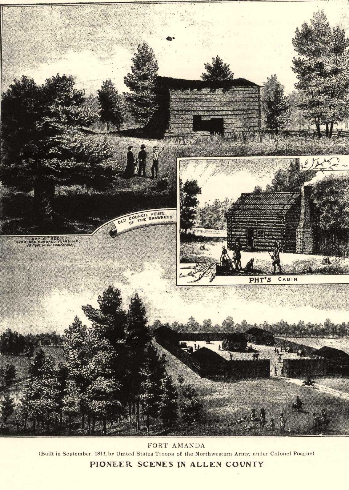
AND REPRESENTATIVE CITIZENS - 51
Arthur in 1817; in 1819 his son James was born.
The first court held in the county was held March 8, 1834, in a blockhouse, the residence of Hon. William McCloud, at Fort McArthur, McCloud being one of the associate judges. The first county officers were elected the following month, the total vote being only 63. Little or no business was done at the first term of court.
The next year when a trial by jury was required, the sheriff found great difficulty in impaneling a jury, the farmers being busy and the country sparsely settled. On the morning of the second day, the judge opened court and asked the sheriff if the jury was full. The sheriff replied : "Not quite full yet. I have eleven men in the jail and my dogs and deputies are out after the twelfth man."
The jail at that time was a log cabin near the fort. The court room was a shed constructed from the side of the blockhouse, with clapboards, with forked saplings for uprights. The benches for the jury and spectators were split puncheons with pins in for legs. The judge was provided with a table and a chair. The jury retired to the woods for their deliberations. In the spring of 1833, the State committee, appointed by the Legislature, selected a site for the county seat on the north bank of the Scioto on part of sections 33 and 34 in Pleasant township, George Houser, Jacob Houser and Lemuel Wilmoth giving 40 acres of their land as an inducement. The committee, having decided upon the site, were unable to agree upon the name but after its selection rode over three miles west with Wiliam McCloud to Fort McArthur where he resided in a blockhouse, to get dinner. McCloud was a great hunter, and his good lady had provided an appetizing dinner of wild meat, for they were very hungry. The subject of a name being discussed, they left it to the decision of Mrs. McCloud who declared in favor of Kenton, in honor of a friend of her husband.
The marsh lands of the county comprise fully 25,000 acres, or about 39 square miles, the Scioto having about 16,000 acres, Hog Creek about 8,000, and about 1,000 acres belonging to the Cranberry marsh. They are all well drained and are mostly fine farming lands, on which are raised immense crops of onions and potatoes.
Hardin County has the following cities and villages with population as follows, according to the census of 1900:
Patterson |
219 |
Ridgeway |
447 |
McGuffey |
452 |
Alger |
462 |
Mount Victory |
734 |
Forest |
1,115 |
Dunkirk |
1,222 |
Ada |
2,576 |
Kenton |
6,852 |
The population of Hardin County in 1830 was 210, and in 1900, 31,187.
HENRY COUNTY
Was formed April 1, 1820, from the Indian territory, and named for Patrick Henry, the Virginia orator and patriot of Revolutionary times. It is a part of the Black Swamp. It was heavily timbered, which delayed its settlement for many years, until railroads, sawmills and stave factories opened up a market for the timber at remunerative prices. The soil is largely of the swamp order with occasional ridges. The swamp lands were originally coverwith black walnut, ash, butternut, beech and hickory.
Napoleon, the county seat, was platted in 1832, and the first dwelling was erected—a log cabin 12 by 14 feet—by Amos Andrews. and used as a tavern.
52 - HISTORY OF VAN WERT COUNTY
One of the Girtys resided about five miles above Napoleon at what is known as Girty's point. There seems to be a difference .of opinion as to which one. Howe gives it as his opinion that it was George Girty, a brother of Simon. He was an Indian trader, and of as infamous a character as Simon. Howe gives a description of the Girty family, from which the following is taken. The father of the Girtys came from Ireland and settled in Pennsylvania. He was beastly intemperate and nothing ranked higher in his estimation than a jug of whisky. "Grog was his song and grog would he have." His sottishness turned his wife's affections. Ready for seduction, she yielded her heart to a neighboring rustic who to remove all obstacles to their wishes knocked Girty on the head and bore off the trophy of his prowess. Four sons of this interesting couple were left—Thomas, Simon, George and James.
The three latter were taken prisoners in Braddock's war by the Indians. George was adopted by the Delawares, became a ferocious savage and died in a drunken fit. James was adopted by the Shawnees and became as depraved as his other brothers. It is said he often visited Kentucky at the time of its first settlement and inflicted most barbarous tortures on all captive women who came within his reach. Traders who were acquainted with him have related that so ferocious was he that he would not have turned on his heel to save a prisoner from the flames. To this monster are to be attributed many of the cruelties charged to his brother Simon. Yet he was caressed by Proctor and Elliott, the British generals.
Simon was adopted by the Senecas and became an expert hunter. In Kentucky and Ohio he sustained the character of an unrelenting barbarian. To women and children in particular nothing was more terrifying than the name of Simon Girty. At that time it was believed by many that he had fled from justice and sought refuge among the Indians, his attachment for them being stronger than for his own people, and his cruelty being the result of his inborn humanity, urged on by the excesses perpetrated by the whites that in many cases were scarcely less inhuman than those of their savage foes.
It is but fair to publish another version of the death of the father of the Girty boys, which seems to be borne out by succeeding events.
Willshire Butterfield says that the elder Girty met his death, in a drunken frolic in his own house, by an Indian named "The Fish." John Turner, who lived with the Girtys, avenged his murder by killing The Fish, two years later marrying Mrs. Girty, who was a reputable woman. When Fort Greenville on the Juniata was taken in 1756, Turner, wife and children were carried into captivity. Turner was recognized as the slayer of The Fish, and was put to death in the most inhuman manner. It is said that Thomas Girty, the oldest son, soon after escaped and lived a useful life, dying on Girty's Run near Pittsburg in 182o. Thus only one of the four brothers improved their opportunity for a good and useful life.
During the Dunmore expedition, Simon Girty acted as. scout and it is said interpreted the Mingo chief Logan's speech to Gibson. Simon Girty, Mathew Elliott and Capt. Alexander McKee, the latter, two Indian traders, deserted from Fort Pitt and made their way to Detroit to join Lieutenant Governor Hamilton, the British commandant. On their way they stopped at Coshocton among the Delawares, and then at the Shawnee towns on the Scioto. They met James Girty, who was engaged in trade with the Indians and easily persuaded him to espouse the British cause. They entered the British service and were sent by
AND REPRESENTATIVE CITIZENS - 53
Hamilton—Simon to the Mingoes and James to the Shawnees—to keep the Indians in line for the British.
George Girty was at this time a lieutenant in the Continental Army. A year later in 1779 he deserted to the British.
Reports are conflicting as to the death of Simon Girty. One has it that he met his death at Proctor's defeat, and was killed by Colonel Johnson's men ; the other, that he retired to his farm near Malden, where he spent the last few years in great suffering, being entirely blind and crippled with rheumatism, and that he died there, and was buried on his farm, the British soldiers from Malden firing a salute over his grave.
Daniel M. Workman, a resident of Logan County, gave the following account of Simon Girty. He said: "I went to Malden and put up at a hotel kept by a Frenchman. I noticed in the bar room a grey-headed and blind old man. The landlady, who was his daughter, a woman of about thirty years of age, inquired of me, 'Do you know who that is ?' pointing to the old man. On my replying, `No', she rejoined, `It is Simon Girty.' He had then been blind about four years. He died about two years later."
Henry County has the following cities and villages with their population, according to the census of 1900:
Florida 276
Malinta 357
Hamler 574
Liberty Center 606
McClure 660
Holgate 1,237
Deshler 1,628
Napoleon 3,639
Henry County in 183o had 262 population and in 1900, 27,282.
LUCAS COUNTY.
This county was formed in 1835 and was named for Robert Lucas, Governor of Ohio from 1832 to 1836. A large portion was formerly included in the Black Swamp. That part of the county bordering on Lake Erie has .a sandy soil. The most important event that transpired in the Indian wars took place near the site of Maumee City. General Wayne had planned to take the Indians by surprise and for that purpose had two roads cut—one by way of Fort Wayne and the other by way of St. Marys. While the British and Indians were watching these, he took a middle route by way of Fort Adams on the St. Mary's River near where the Van Wert and Celina road crosses that stream, passing through Van Wert, and on what was known to the early settlers as the Defiance trail. He would have taken the Indians by surprise had not a deserter notified them of the approach of the army. He then established and erected Fort Defiance at the junction of the Auglaize and Maumee.
On the 13th of August, 1794, Wayne sent one, Christopher Miller, who had lived among the Shawnees, as a special messenger to offer terms of friendship. Becoming impatient at the delay, he moved forward on the 16th and met Miller on his return with the message that if the Americans would wait to days at Grand Glaize (Fort Defiance) the Indians would decide for peace or war. On the 18th the army arrived at Rock de Boeuf, just south of the site of Waterville, where they erected some slight works as a place of deposit for their heavy baggage, which was named "Fort Deposit." During the 19th the army labored at their works and about 8 o'clock on the morning of the 20th moved forward to attack the Indians, who were encamped on the bank of the
54 - HISTORY OF VAN WERT COUNTY
Maumee at and around a hill called "Presque Island," about two miles south of the site of Maumee City, and four south of the British fort, Miami.
General Wayne, in his report of the battle says : "The Legion was on the right flank covered by the Maumee, one brigade of mounted volunteers on the left under Brigadier General Todd, and the other in the rear under Brigadier General Barbee. A select battalion of mounted volunteers moved in front of the Legion, commanded by Major Price, who was directed to keep sufficiently advanced so as to give timely notice for the troops to form in case of action, it being yet undertermined whether the Indians would decide for peace or war.
"After advancing about five miles, Major Price's corps received so severe a fire from the enemy, who were secreted in the wood and high grass, as to compel them to retreat. The Legion was immediately formed in two lines, principally in close thick woods, which extended for miles on our left and for a very considerable distance in front, the ground being covered with old fallen timber, probably occasioned by a tornado, which rendered it impracticable for cavalry to act with effect, and afforded the enemy the most favorable covert for their mode of warfare. The savages were formed in three lines within supporting distance of each other and extending for near two miles at right angles with the river.
"I soon discovered from the weight of the fire and extent of their lines, that the enemy were in full force in front, in possession of their favorite grounds and endeavoring to turn our left flank. I therefore gave orders for the second line to advance and support the first, and directed General Scott to gain and turn the right flank of the savages with the whole force of the mounted volunteers 1w a circuitous route; at the same time I ordered the front line to advance and charge with trailed arms, and rouse the Indians from their coverts at the point of the bayonet and, when up, to deliver a close and well-directed fire on their backs and follow with a brisk charge, so as not to give them time to load again. I also ordered Captain Campbell, who commands the legionary cavalry, to turn the left flank of the enemy next to the river and which afforded a favorable field for that corps to act in. All of these orders were obeyed with spirit and promptitude, but such was the impetuosity of the charge by the first line of infantry, that the Indians and Canadian militia and volunteers were driven from all. their coverts in so short a time that although every possible exertion was used by the officers of the second line of the Legion, and by Generals Scott, Todd, and Barbee of the mounted volunteers to gain their proper positions, but part of each could get up in season to participate in the action, the enemy being driven in the course of one hour more than two miles through the thick woods already mentioned, by less than half their numbers. From every account the enemy amounted to two thousand combatants. The troops actually engaged against them were less than nine hundred. This horde of savages with their allies abandoned themselves to flight, and dispersed with dismay and terror, leaving our victorious army in full, quiet possession of the field of battle, which terminated under the influence of the guns of the British garrison.
"The bravery and conduct of every officer belonging to the army, from generals clown to ensigns, merits my highest approbation. There were some whose rank and situation placed their conduct in a very conspicuous point of view, and which I observed with pleasure and most lively gratitude, among whom I must beg leave to mention Brigadier General Wilkinson and Colonel Hamtramck, the commanders
AND REPRESENTATIVE CITIZENS - 55
of the right and left wings of the Legion, whose brave example inspired the troops. To those I must add the names of my faithful and gallant aides-de-camp, Captain DeButt and T. Lewis, Lewis, and Lieutenant Harrison, who with Adjutant General Major Mills rendered the most essential service by communicating my orders in every direction and by their conduct and bravery inciting the troops to press for victory.
"The loss of the enemy was more than that of the federal army. The woods were strewed for a considerable distance with the dead bodies of Indians and their white auxiliaries, the latter armed with British muskets and bayonets. We remained three days and nights on the banks of the Maumee, in front of the field of battle, during which time all the houses and corn fields were consumed and destroyed for a considerable distance, both above and below Fort Miami, as well as within pistol shot of the garrison, who were compelled to remain tacit spectators to this general devastation and conflagration, among which were the houses and stores and property of Colonel McKee, the British Indian agent and principal in stimulating the Indians in the war now existing between the United States and the Indians."
The loss of the Americans in this battle was 33 killed and 10o wounded. One of the Canadians captured stated that there were 1,400 Indians and 70 Canadians, and that Captain McKee, Captain Elliott and Simon Girty were on the field but at a safe distance in the rear. A soldier that had become detached from the main body met a single Indian in the woods when they attacked each other. A few days later they were found with the soldier's bayonet in the body of the Indian and the Indian's tomahawk in the brain of the soldier.
Several months after the battle of the Fallen Timber, a number of Pottawattamie Indians came to Fort Wayne, where they expressed a desire to see "The Wind" as they styled General Wayne. It is said that when the attack on the Indians, who were concealed behind the fallen timber,, was commenced by ordering the regulars up, the late General Harrison, then being lieutenant with the title of major, addressed his superior: "General Wayne, I am afraid you will get into the fight yourself and forget to give me the necessary field orders," "Perhaps I may," replied Wayne, "and if I do, recollect the standing order for the day is `charge the d__d rascals with the bayonets.' "
It is not necessary to follow closely the progress of internal improvements in Toledo. After the northern boundary line of Ohio was permanently located, there were no doubts as to the future of one or the other of the town sites of Vistula or Port Lawrence. Three lots, 60 by 120 feet at the corners of Monroe and Summit streets were offered for $50 each in 1833, but the opening of the canal in 1845 and the subsequent centering of so many railroads has made Toledo develop into a city almost in a night. In 1833 the two rival towns Vistula and Port Lawrence were united under the name "Toledo."
Lucas County has the following cities and villages within her borders, with population according to the census of 1900:
Sylvania 617
White House 621
Waterville 709
Maumee 1,856
Toledo 131,822
Lucas County had a population of 9,382 in 1840, and 153,559 in 1900.
MERCER COUNTY
Was formed out of the Indian lands, April 1, 1820. The soil is wet and swampy in its
56 - HISTORY OF VAN WERT COUNTY
native state, but easily drained and very fertile. The county was named for Gen. Hugh Mercer, who fell at the battle of Princeton, January 3, 1777.
This county was the scene of one of the most important events in the history of the West—St. Clair's defeat. It took place in the southwest corner of the county within two miles of the State line. The great object of :St. Clair's campaign was to establish a mililtary post at the Miami village at the junction of the St. Mary's and St. Joseph rivers at what is now Fort Wayne, Indiana, with intermediate posts between it and Fort Washington (Cincinnati) to awe and curb the Indians in that quarter, as the only preventative of future hostilities.
Acting under instructions, St. Clair organized his army and at the close of April, 1791, he was at Pittsburg, to which point troops and munitions of war were being forwarded. On the 15th of May he reached Fort Washington, but owing to various hindrances, among which was mismanagement of the quartermaster's department, the troops instead of being ready to start upon the expedition by the first of August, as was anticipated, were not prepared for many weeks later. From Fort Washington the troops were advanced to Ludlow Station, six miles distant. Here the army continued until 'September 17th, when, being 2,300 strong exclusive of militia, it moved forward to a point on the great Miami, where was built Fort Hamilton. Thence they moved 44 miles farther and built Fort Jefferson, which they left on the 24th of October and began their toil-some march through the wilderness.
During this time a body of militia amounting to 300 deserted and returned to their homes. The supplies for the army being still in the rear, General St. Clair, entertaining fears that the deserters might meet and seize them for their own use, determined to send back the First
Regiment for the double purpose of bringing up the provisions and if possible of overtaking the deserters. This arrangement having been made, the army resumed its march, and on the 3rd of November arrived at a creek running to the southwest, which was supposed to be the St.. Mary's, one of the principal branches of the Maumee, but was 'afterward ascertained to be a branch of the Wabash. It being then late in the afternoon, and the army much fatigued by a laborious march, they were encamped on a commanding piece of ground, having the creek in front. It was the intention of the General to occupy that position until the First Regiment with the provisions should come up. He proposed on the next day to commence a work of defense agreeable to a plan agreed upon between himself and Major Ferguson, but he was not permitted to do either, for, on the next morning, November 4th, half an hour before sun up, the men having just been dismissed from parade, an attack was made on the militia posted in front, who gave way and rushed back into camp, throwing the army into a state of disorder from which it could not be recovered, as the Indians followed close at their heels. The redskins were, however, checked a short time by the first line, but immediately a very heavy fire was commenced on that line and in a few minutes it was extended .to the second. In each case the great weight of the fire was directed to the center, where the artillery was placed, from which the men were frequently driven with great slaughter. In that emergency resort was had to the bayonet. Colonel Darke was ordered to make the charge with a part of the second line, which order was executed with great spirit. The Indians immediately gave way, and were driven back several hundred yards, but, for want of a sufficient number of riflemen to preserve the advantage gained, the enemy soon renewed the attack and
AND REPRESENTATIVE CITIZENS - 57
the American troops in turn were forced to give way. At that instant the Indians entered the American camp on the left, having forced back the troops stationed at that point. Another charge was ordered and made by the battalions of Majors Butler and Clark with great success.
Several other charges were afterward made and always with equal success. These attacks, however, were attended with heavy loss of men and particularly of officers. In the charge made by the Second Regiment, Major Butler was dangerously wounded and every officer of that regiment fell except three, one of whom was shot through the body. The artillery being silenced and all the officers belonging to it killed but Captain Ford, who was dangerously wounded, and half the army having fallen, it became necessary to gain the road if possible and make a retreat.
For that purpose a successful charge was made on the enemy as if to turn his right, but in reality to gain the road, which was effected. The militia then commenced a retreat followed by the United State troops, Major Clark with his battalion covering the rear. The retreat as might be expected became a flight. The camp was abandoned and so was the artillery for want of horses to move it. The men threw away their arms and accouterments even after the pursuit was abandoned, which was not continued more than four miles. The road was almost covered with these articles for a great distance. All the horses of the General were killed and he was mounted on a broken-down pack horse, that could be scarcely forced out of a walk and it was impossible for him to get forward in person to command a halt till regularity could be restored, and the orders which he dispatched by others for that purpose were wholly unattended to. The rout continued to Fort Jefferson, where they arrived about dark, 27 miles from the battleground. The retreat commenced at half-past 9 and as the battle began at half an hour before sunrise it must have lasted three hours, during which time with one exception the troops behaved with great bravery. This fact accounts for the immense slaughter that took place.
The only charge alleged by the general against his army was want of discipline, which could not be acquired during the short time they had been in the service. But at this late day the general public has reason to lay serious charges against a general that would send half his army back for provisions without entrenching the small remainder while in the enemy's country. And worse yet, to place raw militia a quarter of a mile in front of regular, troops. Either one was enough to lose the battle. Had he placed the militia where they would have had the example and assistance of the regular troops, instead of being the cause of throwing the army into confusion, no doubt the result would have been different; or, if he had retained the First Regiment until the army was entrenched the result would have been altogether different.
It is plain at this day that this was a battle lost by the commanding officer.
And a part of the responsibility lays still farther back than the General. It is said that General St. Clair was suffering with a painful disease, so that he could not mount or dismount his horse alone. Such an officer should never been put in command of an army in the enemy's country.
Place the blame where the blame properly belongs—on those in authority and an incompetent officer—and not on the brave troops that gave their lives, a sacrifice to some one's blunders.
Two years later Gen. Anthony Wayne sent a detachment to the battleground of St. Clair's
58 - HISTORY OF VAN WERT COUNTY
defeat, where they arrived on Christmas Day, 1793. The next day they gathered what bones they could find above ground and buried them, 600 skulls being found among them. After the bones of the brave men had been buried, a fort was built and named `"Fort Recovery," in commemoration of the battlefield being recovered from the Indians, who had possession of it in 1791. On the completion of the fort, one company of artillery and one of infantry were left, while the rest returned to Greenville.
Two years later the site of St. Clair's defeat, now Fort Recovery, was again the scene of strife and bloodshed. On the 30th of June, 1794, a very severe and bloody battle was fought under the walls of the fort between a detachment of American troops, consisting of 90 riflemen and 50 dragoons, commanded by Major McMahan, and a very numerous body of Indians and British, who at the same instant rushed on the detachment and assailed the fort on every side with great fury. They were repulsed with heavy loss but again rallied and renewed the attack, keeping up during the whole day a heavy and constant fire, which was returned with spirit and effect by the garrison. The succeeding night was foggy and dark and gave the Indians an opportunity of carrying off their dead by torchlight, which occasionally drew fire from the garrison. They, however, succeeded so well that there were only eight or ten bodies left on the ground, which were too near the garrison to be approached.
On the next morning McMahan's detachment having entered the fort, the enemy renewed the attack and continued it with great desperation during the day but were ultimately compelled to retreat from the same field on which they had been proudly victorious on the 4th of November, 1791.
The expectation of the assailants must have been to surprise the fort and carry it by storm, for they could not possibly have received intelligence of the movement under the escort of Major McMahan, which only marched from Greenville on the morning previous, and on the same evening deposited in Fort Recovery the supplies it had conveyed. That occurrence could not therefore have led to the movement of the savages.
Judging from the extent of their encampment and their line of march—in 17 columns forming a wide and extended front—and from other circumstances, it was believed that their numbers could not have been less than 1,500 to 2,000 warriors: It was also believed that they were in want of provisions as they had killed and eaten a number of pack-horses in their encampment on their return seven miles from Fort Recovery, where they remained two nights, having been much encumbered with their dead and wounded.
It was afterward ascertained that there were a considerable number of British soldiers and Detroit militia engaged with the savages on this occasion.
In making his preparations for an advance on the site of Fort Defiance, General Wayne caused two roads to he cut—one by way of Fort Wayne and the other by way of St. Marys—so that the Indians might be kept watching and guessing.
He started on the march July 28th, and halted at Girty's town at the crossing of the St. Mary's River and there erected Fort Adams at a point less than a mile east of the Van Wert and Celina road. He then by rapid marches, avoiding both the roads that had been cut as blinds, moved his army by a middle route through Van Wert County. What was known as Wayne's trail was visible from Van Wert north for many years after the settling of the county.
AND REPRESENTATIVE CITIZENS - 59
The Grand Reservoir in Mercer County is said to be the largest artificial lake in the world. It is situated on the summit between the Ohio River and the lakes, and is about nine .miles long and from two to four. miles wide. It was constructed by raising two walls of earth from to to 25 feet high, one at the east and the other at the west end of the reservoir. The east one is about two miles and the other about four miles long. These walls with the high ground at the north and south sides form the basin of this large body of water. About one half of the land was a level prairie, the remainder timber. The timber was cut down and the action of the water has preserved it and it lies there today as solid as the day the water first covered it.
The reservoir, was commenced in 1837, completed in 1845 and cost $600,000. It covers an area of 17,600 acres, and has an average depth of to feet of water.
Before the construction of the reservoir, several persons had purchased and improved land within the boundary. Before the completion of the reservoir a resolution was introduced in the Legislature of Ohio, and passed by a unanimous vote declaring that no water should be let into the reservoir before the same was cleared of timber and the parties paid for this land. An appropriation of $20,000 was made for this purpose, but this was squandered by the officers and land speculators. When the banks were completed and the water let in, it submerged most of the land within the boundary of the reservoir.
On May 3, 1843, a meeting was held in Celina with Samuel Buckman, Esq., county commissioner, acting as president. It was unanimously resolved that Benjamin Linzee, Esq., should go to Piqua, the headquarters of the Board of Public Works, and lay their grievances with an address before the members of that body. Mr. Linzee having performed his duty, Messrs. Spencer and Ramsey returned the sneering answer, "Help yourselves if you can."
On May 12th the meeting requested Mr. Linzee to return to Piqua with the answer that if the board did not pay for the land or let off the water, the citizens would cut the bank on the 15th. The reply came hack, "The `Piqua Guards' will be with you and rout on that day." When this response was heard by the people, the muttering thunder around the reservoir was not only loud but deep—every person was excited.
On the morning of the 15th at 7 o'clock, more than too citizens with shovels, spades and wheel-barrows were on the spot ready for work. The place selected was the strongest on the bank in the old Beaver channel. The object of the people was not to damage the State, and the dirt was wheeled back on the Lank On each side.
It employed the men a day and a half before the cutting was complete. It was dug six feet below the level of the water, and a flimsy breastwork was made to hold hack the water when the tools were taken out. When all was ready, Samuel Buckman said, "Who will start the water?" "I," said John Sunday, "I," said Henry Linzee, and in a moment the meandering waters were hurling down 50 yards below the bank. It was six weeks before the water subsided.
As soon as this was known at headquarters, warrants were sworn out for all who were engaged in the work. Thirty-four of the leaders, comprising all the county officers—judges, sheriff, clerk, auditor, treasurer, deputy treasurer, recorder and surveyor—with merchants, farmers and private citizens, were all arrested and bound over to the next term of court. The grand jury refused to find a bill for misde-
60 - HISTORY OF VAN AVERT COUNTY
meanor and so the matter ended. It cost the State $17,000 to repair the damage.
The reservoir is a beautiful inland lake and was a great place for fishing until the State officials, in a mistaken idea of economy, leased, the lands for oil and thus for the sake of a penny destroyed a dollar. The parties responsible for the leasing should have been met by the jeers of all good citizens the State over. It was little, if any, less than a crime.
The population of the county, in 1830, then including St. Marys—now in Auglaize the most populous part of the county—was 1,100. In 1900 it had a population of 28,021, including the following towns: Chickasaw, 310; Montezuma, 317; Mendon, 599; Cold Water, 627; Fort Recovery, 1,097; Rockford, 1,207; and Celina, 2,815.
PAULDING COUNTY.
This county was formed from the territory ceded by the Indians in the treaty signed in 1818, and was organized in 1820 and named for John Paulding, one of the captors of Major Andre, the British spy.
The greater part of the county was low, wet swampy land and very heavily timbered with oak, black ash, elm and cottonwood. From the date of the completion of the canals, it was visited every year by French Canadians after ship timber., which was rafted down the canal to Toledo, and shipped from there to England. They frequently entered the land and after taking off the ship timber would abandon the land as worthless. But little attempt was made to settle the county except along the Auglaize River, or by persons who depended upon hunting and hauling hoop-poles for a living, until the advent of the stave factories. Then the elm and cottonwood, which had been looked upon as worthless. became mostvaluable. Stave factories were located along the railroads and the chopping of the axeman could be heard in every direction. The forests disappeared as if by magic. When the timber was gone, the land passed largely into new hands and farms were rapidly cleared. The land being level and wet, a system of ditching was necessary. In this the pioneers of Paulding were in advance of all others. Ditches were located that were real canals; streams were ditched and in a few years the swamp was changed to a fertile field. With six railroads the improvement was most rapid. Land that a few years ago could be entered for $1.25 an acre is now selling for $100 an acre. The county also came to the front in the matter of roads. They built their roads at great expense and then kept them in good condition, and were almost among the first in Northwestern Ohio to commence piking. While Paulding County to appearance is almost perfectly level, yet it has good drainage, the Auglaize and Maumee being the largest streams, with numerous smaller ones that empty into them.
The first court was held in 184o in Rochester by Judge Emory D. Potter, president judge, with Associate Judges Nathan Eaton, John Hudson and Gilman C. Mudgett. Rochester at that time contained about 20 families, but since has disappeared from the map. From there the county seat was moved to Charloe, in 1841, where it remained until it was moved to Paulding Center, now Paulding.
Charloe was formerly an Indian village of about 600 persons, under Chief Occanoxa. He was a powerful Indian and had in his time been a great warrior; he was wont to boast of the women and children that he had scalped. Charloe was named for an Indian chief of that name who acquired considerable fame as an orator and statesmen.
Paulding. the present county seat. was laid
AND REPRESENTATIVE CITIZENS - 61
out by a company composed of Aughenbaugh, Riley, Marsh and Hedges, but was not made the county seat for a number of years. The county was the favorite hunting grounds of the Indians, and also of the whites for many years after the Indians left. For many years coonskins were a legal tender, and frequently purchased marriage licenses. The first trading house in the county was opened by Thomas P. Quick—this was for the purpose of trading with the Indians. The next was opened by Horatio N. Curtis. The first white man that settled in the county was John Driver., a silversmith, who had a profitable trade with the Indians. Driver was quiet and could never be prevailed upon to reveal his early history or the place of his nativity.
Paulding, the county seat, is situated on the Cincinnati Northern Railroad and in 1900 had a population of 2,080. It is growing rapidly. The following villages are situated in Paulding County and had the population set opposite their names in 1900:
Haviland 186
Broughton 226
Cecil 326
Oakwood 342
Melrose 383
Latty 444
Scott 547
Grover Hill 655
Antwerp 1,206
Payne 1,336
In 1864 Graft, Bennett & Company, of Pittsburg, established a furnace, for the purpose of making charcoal iron, between Cecil and Paulding on the banks of the Wabash and Erie Canal and built a railroad from Cecil to Paulding. The charcoal was burned in kilns built in the shape of the old-fashioned beehives. They were made of fire brick and plastered with lime. These were filled with cord wood and it took about four days to burn a kiln and a cord of wood would produce 50 bushels of charcoal. The furnace employed about 250 men in cutting cordwood and burning charcoal._ The ore was shipped from Lake Superior on the lakes to Toledo, and then on the canal and railroad to the furnace. They cleared annually about 1,000 acres of land, and used 120 cords of wood a day to make 45 tons of iron.
Charcoal iron was far superior to that made with bituminous coal. Science has now overcome the difference in qualify and a charcoal furnace is a back number. The fires were drawn in the furnace and the land made into farms.
Paulding was the headquarters of the hoop manufacturing business, as well as that of staves. Black ash hoops were made by splitting out the timber in pieces the width of a hoop and the depth of half a dozen hoops; these were then started at the end with the frow and then put in what was called a break; by bearing down on the piece the split that had been started at he end would follow on down to within 10 inches of the end—this was left to hold the hoops together. An expert hoop-maker would make from $4 to $6 a day. They were used for making slack barrels, nail kegs, etc. Then came the round hoops,. made of hickory and oak poles. They were made by splitting the poles in halves and, if large, in quarters, and then shaving them. These were used for tight barrels, such as pork barrels, syrup and liquor barrels. Next came the elm hoops, which were made by machinery. The timber was first sawed into planks the proper thickness, next steamed and cut by a machine something in the manner staves are curt. after which they were run through a planer, finally being coiled, eight hoops in a coil.
Slack barrel staves, made from elm and
62 - HISTORY OF VAN WERT COUNTY
red oak, were also cut by machinery. The timber was sawed into lengths for a barrel and split into bolts; these were steamed and then cut in a machine. The heading was made from ash, cottonwood and basswood, being sawed out and turned in a machine used for that purpose.
But all this is in the past. Where the dense forests once stood there are now immense corn fields.
In 1830 Paulding County had a population of 161; in 184o, 1,034; in 185o, 1,766; in 186o, 4,945 ; in 1870, 8,544; in 1890, 25,932 ; in 1900, 27, 528.
When the Wabash and Erie Canal was built, a reservoir was constructed by damming a small steam and building dykes. Thus about 2,000 acres were enclosed. When the State of Indiana abandoned the canal, the reservoir became worthless and a menace to health, and an effort was made to have the State abandon it, but the bill failed to pass. On the night of April 25, 1888, about 200 men proceeded to the lower end of the reservoir, blew up two locks and the bulk head at the lower end of the reservoir and burned the buildings. As there was no object in the State repairing the break, the Legislature passed the necessary act to complete the destruction and the land was ordered sold.
PUTNAM COUNTY
Was formed from the old Indian territory, April 1, 1820, and named for Gen. Israel Putnam, who was born at Salem, Massachusetts, January 7, 1718, and died at Brooklyn, Connecticut, May 29, 1790. The county was not organized until 1834, having been attached to Williams for judicial purposes.
The surface of the county is level. It was a part of the Black Swamp and was coveredwith heavy timber—black ash, white elm, cottonwood, and burr oak. What is known as the Sugar Ridge passes entirely across the county and is much higher than the surrounding country; it has a sandy soil and was originally covered with black walnut, butternut, gray ash, red elm, beech, red oak, and sweet oak. Much of the timber was of very large size and would have been quite valuable if it could have been saved until there could have been transportation facilities for properly marketing it. But as this timber was on the highest ground it was the first cleared, and many valuable trees were burned in log heaps. The western part of the county was largely settled by German Catholics. The more central part was settled with what are known as Mennonites. They have peculiar notions about dress, and, while of the best quality it must be made very plain. For many years they did not vote, except at school elections.
A few years ago a daughter of one of this sect with her husband, also a Mennonite, moved West and adopted the fashion in vogue in the neighborhood. After an. absence of several years, wishing to visit her former home, she wrote to a friend in Delphos to procure a Mennonite bonnet for her, as she would not wound the feelings of her parents by wearing her hat. She secured her bonnet at Delphos, leaving her hat, and made her visit; when she returned West she stopped at Delphos, left her Mennonite bonnet and donned her hat.
There were two Indian towns in Putnam County, known as Upper and Lower Tawa towns. Fort Jennings was erected on the bank of Jennings Creek. during General Wayne's campaign against the Indians, for the purpose of keeping open his line of supplies. Howe. in his "Historical Collections of Ohio," gives a description and picture of the first house that was built in Putnam County, erected on the
AND REPRESENTATIVE CITIZENS - 65
Auglaize by Sebastian Sroufe. It was a double log cabin with a space between, which was covered by the same roof.
He also gives an amusing account of capturing a strange animal. He says that after killing it, and thinking it a valuable specimen, he tied it on his horse behind the saddle. His horse began to dance up and down, especially the back part of him, and then trotted off. He had hard trouble to catch him, and was fearful he would have to pass the night in the Black Swamp. A quantity of quills were sticking in his back, gathered from the animal, which proved to be a porcupine. Kalida was originally the county seat, but in 1866 the seat of government was moved to Ottawa, the Court House at Kalida having burned down, and Ottawa having been chosen by the vote of the people.
H. S. Knapp, who at an early day took charge of the Kalida Venture, says that he and his wife went to Columbus Grove to a camp meeting, and were dumped in a mudhole; that he tried to pull his wife out, but couldn't, so he backed his horse up and his wife took hold of its tail and was pulled out. William Galbraith tells that his neighbors, an Indian and his wife and their papoose, had a quarrel ; the husband pulled out his knife and cut the papoose in two ; each having half, this settled their quarrel.
Stansbury tells of a novel way to punish a thief. Indian Tom was a bad Indian. In the spring of 1834 he stole a pony of one of the tribe. He was arrested, tried and convicted. They took him from the camp and divesting him of his clothing tied him to a tree and there left him to remain all night, subject to the tortures of the mosquitoes.
Among the men of note of Putnam County might be mentioned Benjamin Metcalf, James McKenzy, George Skinner. Abraham Sarber,
Dr. Godfrey and C. H. Rice. Gen. A. V. Rice, a son of C. H. Rice, was a gallant soldier during the War of the Rebellion, serving from the 27th of, April, 1861, to the close of the war. He was wounded in the battle of Shiloh, where he commanded the 57th Ohio; as lieutenant colonel. He was actively engaged in all the movements of Sherman's army in the siege of Corinth in 1862; also, in the siege of Vicksburg, and was recommended by General Sherman for promotion to brigadier general. In the Atlanta campaign to took part in the battles of Sugar Valley, Resaca, Dallas, New Hope, Big Shanty, and Little Kenesaw from the 5th of May to the 27th of June, 1864. When at the assault of Little Kenesaw he received three wounds simultaneously, one resulting in the amputation of the right leg above the knee, one shattering the left foot, and the third wounding him in the head. For his action at Resaca, Georgia, May 14, 1864, he again received an impromptu recommendation from the general officers' for promotion to brigadier general for gallant conduct on the field of battle under their personal observation. But the appointment was not made until May, 1865. His wounds kept him out of service until April, 1865, when he rejoined his command at New Bern, North Carolina. After the review at Washington, he took his command to Louisville, Kentucky, where he was assigned to the command of the Third Brigade of the Second Division, 15th Army Corps, which he took to Little Rock, Arkansas, June 24. 1865, and which brigade was mustered out in August, 1865. General Rice was honorably discharged January 15, 1866. His wounded limb caused him great suffering and was mainly the cause of his death. He had one or two operations performed but to no avail.
Putnam County has the following cities and villages, with population in 1900 as follows:
66 - HISTORY OF VAN WERT COUNTY
Miller City 163
Fort Jennings 322
Belmore 324
Gilboa 346
West Leipsic 346
Glandorf 349
Ottoville 369
Dupont 370
Pandora 409
Kalida 622
Continental 1,104
Leipsic 1,726
Columbus Grove 1,935
Ottawa 2,322
Putnam County in 183o had a population of 230, and in 1900, 32,525.
WILLIAMS COUNTY
Was formed from the old Indian territory, April 1, 1820, and organized in April, 1824. It contains about 420 square miles.
The surface is mostly slightly rolling. In the western portion are oak openings with a light sandy soil, with portions of a clayey nature, and in the north a rich black soil.
David Williams, one of the three captors of Major Andre, after whom this county was named, was born in Tarrytown, New York, October 21, 1754, and died near Livingstonville, New York, August 2, 1831. He enlisted in the Revolutionary Army in 1775, and served under General Montgomery at St. Johns and Quebec. During his service his feet were badly frozen, which partially disabled him for life. After the war he bought a farm near the Catskill Mountains.
Among the first settlers in Williams County were James Guthrie, who settled in Springfield township in 1827 ; Samuel Holton, who came to St. Joseph township in the same year ; also John Zediker, John Perkins, Josiah Packard, Rev. Thomas J. Prettyman, Mrs. Mary Leonard and her three sons-in-law, and James Overlease, Sebastian Frame, John Keckman and John Stubbs. The Indians that the whitesfound in this county were of the Ottawa, Miami, Pottawattamie and Wyandot tribes. On the west bank of the St. Joseph River, below the site of the village of Denmark, is a tow piece of meadow land called "The Indian Meadows," on which the Indians raised corn.
Bryan, the county seat, was laid out in 1840, and was named for Hon. John A. Bryan. When Defiance County was formed, there was considerable strife between Williams Center, Pulaski, and the present location for the seat of justice of Williams County, as the former county seat (Defiance) went with the new County. It was finally settled by John A. Bryan donating the grounds for its location, on condition that it bear his name.
The first discovery of artesian water, now obtained in so many parts of the Maumee Valley, was made at Bryan in 1842. The mineral water discharged from the deep well at Stryker, struck at a depth of 230 feet below the surface, is of a different character. It does not overflow in virtue of its own head, but is thrown out periodically by violent discharges of hydrosulphuric-acid gas. This is constantly rising in some amount through the water and at intervals of about six hours finds vent in great volume from some subterranean reservoir, throwing out in a foaming torrent many barrels of water. The water possesses medicinal properties or high value.
Williams County has the following cities and villages within her borders, with population in 1900 as follows :
Blakeslee 239
Alvordton 482
Pioneer 603
Edon 740
West Unity 897
Edgerton 1,043
Stryker 1.306
Montpelier 1,869
Bryan 3.131
AND REPRESENTATIVE CITIZENS - 67
Williams County had a population in 1830 of 387, and in 1900, 24,953.
WOOD COUNTY.
This county, a part of the Black Swamp, was early in the existence of the republic, the field of strife between government troops and the Indians and their scarcely less barbarous alies, the French and English, which struggle was only finally terminated by Wayne's decisive victory. Previous to that no portion of the West was more loved by the Indians than the Maumee Valley and its tributaries. In the daily journal kept by George Will, under date of August 6, 1794, during Wayne's campaign, he says, when within six miles of the Auglaize River, "I expect to eat green corn tomorrow." On the 8th he says, "We have marched four or five miles in corn fields down the Auglaize and there is not less than a thousand acres around the town." This journal, kept from that time until the return of the army to Fort Greenville, is full of the descriptions of the immense corn fields, large vegetables patches and old apple trees along the banks of the Maumee. During the eight days while building Fort Defiance, the army obtained their bread and vegetables from the corn fields and potato patches surrounding the fort. In the march of the army from Fort Defiance to the foot of the rapids, the army passed through several Indian towns constructed of bark and skins, which indicated plainly that the forces that had occupied them were composed not only of Indians, but of Canadian French and renegade Englishmen.
Judge Burnet says that his yearly trips to Detroit, from 1796 to 1802 made it necessary to pass through some of their towns and convenient to visit many, of them. "Of course I had frequent opportunity of seeing thousands of them in their villages and hunting campsand of forming a personal acquaintance with some of their distinguished chiefs. I have eaten and slept in their towns and partaken of their hospitality, which had no limit but that of their contracted means. In journeying more recently through the State, discharging my judicial duties, I sometimes pass over the ground on which I have seen towns filled with happy families of that devoted race, without perceiving the smallest trace of what had once been there."
The first white settler on the Maumee was Col. John Anderson. He settled at Fort Miami in 1800. Peter Manor, a Frenchman, who was here previous to that, and was adopted by the chief, Tontogany, by the name of Sawendebans, or "Yellow Hair," did not come here to reside until 1808. These were the only ones until May, 1810, when came Amos Spafford, Andrew Race, Thomas Learning, Halsey W. Learning, James Carlin, William Carter, George Blalock, James Slason, Samuel H. Ewing, Jesse Skinner, David Hull, Thomas Dick, William Peters, Ambrose Hickox and Richard Gifford, all of whom settled near the foot of the rapids.
When the War of 1812 broke out, there were 67 families residing at the foot of the rapids. Manor, the Frenchman, states that the first intimation the settlers had of Hull's surrended at Detroit manifested itself by the appearance of a party of British and Indians at the foot of the rapids a few days after it took place. The Indians plundered the settlers on both sides of the river and departed for Detroit. Manor won the confidence of a Delaware chief named Sac-a-manc by pretending friendship for the British, and was by him informed that in a few days a grand assemblage of the tribes of the Northwest was contemplated at Malden. and that in about two days after that assemblage a large number of British and Indians be at the foot of the rapids on their
68 HISTORY OF VAN WERT COUNTY
march to relieve Fort Wayne, then under investment by the American Army as was supposed. He also informed him that when they came. again they would massacre every Yankee found in the valley.
Sac-a-manc left in a day or two for the interior of the State. The day after he left, Manor called upon Major Spafford and warned him of the evil intenions of the Indians as he had received them from Sac-a-manc. The Major placed no confidence in them, and expressed his determination to remain until the army from the interior should reach this frontier. A few days after this, a man by the name of Gordon was seen approaching in great haste. He had been raised among the Indians, and Major Spafford had done him some small favor. Major Spafford met him in his cornfield and was informed that a party of about 50 Pottawattamies on their way to Malden had taken this route and that in less than two hours would be at the foot of the rapids. He also urged the Major to make good his escape immediately. Most of the families at the foot of the rapids had left the valley after receiving the news of Hull's surrender.
Major Spafford assembled what remained on the Lank of the river, where they put in tolerable sailing condition an old barge in which some officers had descended the river from Fort Wayne the previous year. They had barely time to get such of their effects as were portable on board and row down to the bend below town. when they heard the Indians' shouts above. Finding no Americans there. they passed on to Malden. The Major and his companions sailed their crazy craft down the lake to the Quaker settlement at Milan. where they remained until the close of the war.
On the breaking up of the ice in Lake Erie, General Proctor with all his disposable force, consisting of regulars and Canadianmilitia from Malden, and a large body of Indians under their celebrated chief, Tecumseh, amounting in all to 2,000 men, laid seige to Fort Meigs. To encourage the Indians, Proctor had promised them an easy conquest, and assured them that General Harrison would be delivered up to Tecumseh.
On April 26th the British columns appeared on the opposite bank of the river, and established their principal batteries on an eminence opposite the fort. On the 27th the Indians crossed the river and established themselves in the rear of the American lines. The garrison not having completed their wells, had no water except what they obtained from the river under the fire of the enemy. On the 1st, 2nd and 3rd of May their batteries kept up a constant fusillade of balls and shells on the fort. On the night of the 3rd the British erected a gun and mortar battery on, the left bank of the river, within 250 yards of the American lines. The Indians climbed trees in the neighborhood of the fort and poured a galling fire upon the garrison. In this situation General Harrison received a summons from Proctor for a surrender of the garrison, greatly magnifying the latter's means of annoyance. This was answered by a prompt refusal assuring the British general that if he obtained possession of the fort, it would not be by capitulation.
The conversation which took place between General Harrison and Major Chambers, of the British Army, was as nearly as can be recollected as follows :
Major Chambers—General Proctor has directed me to demand the surrender of the post. He wishes to spare the effusion of blood."
General Harrison—"The demand under present circumstances is a most extraordinary one. As General Proctor did not send me a summons to surrender on his first arrival, I
AND REPRESENTATIVE CITIZENS - 69
supposed that he believed me to be determined to do my duty. His present message indicates an opinion of me that I am at a loss to account
Major Chambers—"General Proctor could never think of saying anything to wound your feelings, sir. The character of General Harrison as an officer is well known. General Proctor's force is very respectable and there is with him a larger body of Indians than before have been embodied."
General Harrison—"I believe I have a very correct idea of General Proctor's force ; it is not such as to create the least apprehension for the result of the contest, whatever shape he may be pleased to give it. Assure the General that he will never have this post surrendered to him upon any terms. Should it fall into his hands it will be in a manner calculated to do him far more honor, and to give far more claims upon the gratitude of his government than any capitulation could possibly do."
Apprehensive of such an attack, General Harrison had made the Governors of Kentucky and Ohio minutely acquainted with his situation and had stated the urgent necessity of immediate reinforcements for Fort Meigs. His requisitions had been zealously anticipated and General Clay was at this moment descending the Maumee with 1,200 Kentuckians to his relief. At 12 o'clock on the night of the 4th, an officer, Capt. William Oliver, arrived from General Clay with the welcome intelligence of his approach, stating that he was just above the rapids and could reach him in two hours, and requesting his orders. Harrison determined on a general sally, and directed Clay to land 800 men on the right bank, take possession of the British batteries, spike their cannon and then to immediately return to their boats and cross over to the American fort. The remainder of Clay's force was ordered to land on the left bank and fight their way to the fort, while sorties were to be made from the fort in aid of these operations. Captain Hamilton was directed to proceed up the river in a pirogue, land a subaltern on the left bank, who should be a pilot to conduct General Clay to the fort, and then to cross over and station his pirogue at the place designated for the other division to land.
General Clay having received these orders, descended the river in order of battle in solid columns, each officer taking position according to rank. Colonel Dudley, being the eldest in command, led the van and was ordered to take his men in the 12 front boats and execute General Harrison's orders on the right bank. He effected his landing at the place designated without difficulty. General Clay kept close along the left bank until he came opposite the place of Colonel Dudley's landing, but not finding the subaltern there he attempted to cross over and join Colonel Dudley; this was prevented by the violence of the currents of the rapids. He again attempted to land on the left bank and effected it with only 50 men amid a brisk fire from the enemy on shore and made his way to the fort, receiving their fire until within the protection of its guns. The other boats under the command of Colonel Boswell were driven farther down the current and landed on the right to join Colonel Dudley. Here they were ordered to reembark, land on the left bank and proceed to the fort. In the meantime two sorties were made from the garrison, one on the left in aid of Colonel Boswell, by which the Canadian militia and Indians were defeated and Colonel Boswell enabled to reach the fort in safety, and one on the right against the British batteries, which was also successful. Colonel Dudley with his detachment of Soo Kentucky militia completely succeeded in driving the British from their bat-
70 - HISTORY OF VAN WERT COUNTY
teries, and spiking the cannon. Having accomplished their object, his orders were peremptory to return immediately to their boats and cross over to the fort, but the blind confidence which generally attends militia when successful proved their ruin.
Although repeatedly ordered by Colonel Dudley and warned of their danger and called upon from the fort to leave the ground, and although there was abundant time for that purpose before the British reinforcements arrived, yet they commenced a pursuit of the Indians, and suffered themselves to be drawn into an ambush by some feint skirmishing, while the British troops and a large body of Indians intercepted their return to the river. Elated with their first success they considered the victory already gained and pursued the enemy nearly two miles into the woods and swamps, where they were suddenly caught in a defile and surrounded by double their number. Finding themselves in this situation consternation prevailed ; their lines became broken, disordered, and, huddled together in unresisting crowds, they were obliged to surrender to the mercy of the savages.
The following account of the treatment of the prisoners is from the pen of Joseph R. Underwood, a lieutenant of a Kentucky company commanded by Capt. John C. Morrison.
He says that in retreating towards the batteries he received a ball in his back with a stunning force and fell on his hands and knees. "I arose and threw open my waist coat to see if the ball had passed through me; finding it had not, I ran on and had not proceeded more than a hundred yards before I was made prisoner. In emerging from the woods into an open piece of ground near the battery we had taken, and before I knew what had happened, a soldier seized my sword and said to me, `Sir, you are my prisoner.' I looked before me and sawwith astonishment the ground covered with muskets. The soldier, observing my atonishment, said, `Your army has surrendered," and received my sword. He ordered me to go forward and join the prisoners. I did so. The first man I met whom I recognized was David Smith, of our company. With eyes full of tears, he exclaimed, Good Lord, Lieutenant, what does all this mean?' I told him that we were prisoners of war.
"On the march to the garrison. the Indians began to strip us of our valuable clothing and other articles. One took my hat, another my hunting shirt, and a third my waist coat, so I was soon left with nothing but my shirt and pantaloons. On our approach to the garrison the Indians formed a line to the left of the road, their being a perpendicular bank to the right, and on the margin of which the road passed.
"I perceived that the prisoners were running the gauntlet, and that the Indians were whipping, shooting and tomahawking the men as they ran by their line. When I reached the starting place, I dashed off as fast as I was able, and ran near the muzzles of their guns, knowing that they would have to shoot me while immediately in front of then or let me pass, for to have turned their guns up or down the lines to shoot me would have endangered themselves, as there was a curve in the line. In this way I passed without injury except some strokes over the shoulders with their gun sticks. As I entered the ditch around the garrison, the man before me was shot and fell and I fell over him. The passage was stopped, for a while by those who fell over the dead man and myself.
"How many lost their lives at this place I cannot tell, probably between twenty and forty. The brave Captain Lewis was among the number. When we got within the walls
AND REPRESENTATIVE CITIZENS - 71
we were ordered to sit down, I lay in the lap of Mr, Gilpin, a soldier of Captain Henry's company from Woodford, A new scene commenced. An Indian painted black mounted the dilapidated wall and shot one of the prisoners next to him, He reloaded and shot a second, the ball passing through him and entering the hip of another, who afterwards died, I was informed, at Cleveland of the wound. The savage then laid down his gun and drew his tomahawk with which he killed two others, When he drew his tomahawk and jumped down among the men, they endeavored to escape from him by jumping over the heads of each other and thereby to place others between themselves and danger."
William G, Ewing in a letter to John H. James, of Urbana, gives full particulars of Tecumseh's interference on this occasion, which is here copied : "While this bloodthirsty carnage was raging, a thundering voice was heard in the rear in the Indian tongue, when turning around he saw Tecumseh coming with all the rapidity his horse could carry him. He sprang from his horse, caught one by the throat and the other by his shoulders and threw them to the ground. Drawing his tomahawk and scalping knife, he ran in between the Americans and the Indians, brandishing them with the fury of a mad man and daring any one of the hundreds around him to attempt to murder another American, They all appeared confounded and immediately desisted. His mind appeared rent with passion, and he exclaimedalmost with tears in his eyes, 'Oh what will become of my Indians.' He then demanded in an authoritive tone where Proctor was, but casting his eyes upon him at a small distance sternly inquired why he had not put a stop to the inhuman massacre. `Sir,' said Proctor, `your Indians cannot be commanded.' `Begone', retorted Tecumseh with the greatest disdain, `you are unfit to command; go and put on petticoats.' " ,
Following are given the cities and villages of Wood County with their population, according to the census of 1900:
West Millgrove 236
Millbury 280
Custar 293
Bairdstown 298
Milton Center 325
Tontogany 352
Hoytsville 431
Haskins 440
Grand Rapids 540
Portage 546
Jersey City 555
Rising Sun 660
Bloomdale 740
Freeport 815
Cygnet 896
Weston 953
Pemberville 1,081
Bradner 1,148
Perrysburg 1.760
North Baltimore 3.561
Bowling Green 5.067
In 1830 Wood County had a population of 1,102 and in 1900, 51,555,